The Risks Residents Face: Evacuation Fiction vs. Fact on Linda Vista Drive
The developer says the project adds two minutes to evacuation time. The city’s own data shows the roads are already at four times capacity. An independent engineer’s analysis says it’s even worse. Which version should families trust with their lives?
Cupertino Facts • April 2026
This is Part 2 of a three-part investigation into the Evulich Court project approval.
- Part 1: The Paper Trail — The full story of how incomplete information flowed from city staff to HCD to the developer’s lawyers, and how the Fire Chief’s straightforward testimony exposed the gap.
- Part 2: The Risks Residents Face — Evacuation gridlock, flawed studies, and what the city’s own data says about the danger to Linda Vista families. (You are here)
- Part 3: The Architecture of Approval — The developer’s legal strategy to stretch the record, the staff omissions that enabled it, and the circular argument that silenced safety concerns.
One Neighborhood, Two Completely Different Assessments
When the Cupertino City Council voted on the Evulich Court project on April 1, 2026, two evacuation analyses existed for the Linda Vista corridor. They were produced using different methodologies, different assumptions about who would be evacuating, and different assumptions about road capacity. They reached conclusions so divergent that they describe what amount to two different neighborhoods.
The developer’s analysis, produced by Hexagon Transportation Consultants at Summerhill’s request, concluded the project would add just 3.6 percent to evacuation traffic and approximately two minutes to evacuation time. It described the impact as one that “would not significantly affect traffic evacuation volumes or conditions.”
The city’s own analysis, produced by Fehr & Peers — a nationally recognized transportation firm the city had commissioned — found something altogether different. It found that the evacuation routes serving the Linda Vista area were already operating at over four times their design capacity during a wildfire scenario. Not with the project — without it.
How can two professional analyses of the same neighborhood reach such radically different conclusions? The answer lies in what each study chose to count — and what it chose to ignore.
The Hexagon Study: What the Developer Didn’t Count
The Hexagon Transportation analysis, dated February 26, 2026, was submitted by Summerhill’s own team. It was characterized by the developer’s attorneys, in their letter to city staff, as “a voluntary, non-CEQA, informational assessment prepared at the request of the applicant for internal purposes.” In other words, even the developer described it as an informal, voluntary exercise — not a regulatory analysis.
The study’s methodology had two fundamental limitations that dramatically understated the evacuation challenge.
First, it counted only project residents in its evacuation volume estimate. It did not account for the students at nearby Monta Vista High School or Kennedy Junior High, the hikers on the Linda Vista Trail, the commuters on local roads, or the existing residents of the broader Linda Vista neighborhood who would all be evacuating simultaneously. In a wildfire scenario, evacuation demand comes from everyone in the threat zone, not just the residents of a single development.
Second, it assumed a road capacity of 2,700 vehicles per hour — a figure based on clear-sky, ideal driving conditions. It did not adjust for the conditions that actually accompany a wildfire evacuation: heavy smoke reducing visibility, panicked drivers, contraflow from emergency vehicles, or the well-documented breakdown in intersection efficiency that occurs during mass evacuations.
Third, but perhaps most important:
It ignored the capacity of Linda Vista Drive, where all the vehicles from the new development will be exiting into.
Under these favorable assumptions, the study naturally concluded the project’s impact would be minimal — a two-minute delay on a 59-minute baseline.
The Fehr & Peers Study: What the City Already Knew
The Fehr & Peers study used a fundamentally different — and more realistic — methodology. It counted all evacuating populations in the area, including school populations, hikers, and commuters. And it used wildfire-adjusted road capacity of approximately 570 vehicles per hour — a figure that accounts for smoke, low visibility, and emergency panic conditions. This is less than a quarter of the capacity Hexagon assumed.
The results were alarming.
McClellan Road, a key evacuation route, showed a volume-to-capacity ratio of 4.2 — meaning 420 percent of the road’s realistic emergency capacity. Foothill Boulevard showed a ratio of 4.0. Stevens Creek Boulevard registered at 3.6.
What these numbers mean in practice: A volume-to-capacity ratio above 1.0 means the road cannot handle the traffic being placed on it. At a ratio of 4.0, vehicles are not moving through the corridor — they are sitting in gridlock.
This is the scenario that has turned fatal in wildfires from Paradise to Lahaina: not that people didn’t try to evacuate, but that the roads couldn’t carry them.
The city received this study in the September–October 2025 timeframe. It was not included in the Planning Commission’s agenda packet for the February 24, 2026, hearing. It was not referenced in the staff report. Its unlikely to be shared with HCD before HCD issued its March 30 letter. The developer’s attorneys, in their April 1 letter, told the Council there were no “applicable, objective standards related to evacuation routes” — while this study sat in city files.
One Neighborhood, Two Realities
| Factor | Hexagon (Developer) | Fehr & Peers (City) |
| Commissioned by | SummerHill Homes | City of Cupertino |
| Populations counted | Project residents only | All residents, school populations, hikers, commuters |
| Road capacity assumed | 2,700 vehicles/hour (clear sky, ideal conditions) | ~570 vehicles/hour (wildfire-adjusted: smoke, low visibility, panic) |
| Conclusion | 3.6% increase; 2-minute delay | Routes already at 360–420% of capacity |
| Study type | “Voluntary, non-CEQA, internal review” | City-commissioned expert analysis |
| Shared with decision-makers? | Yes — cited in developer’s legal letter | No — not included in Planning Commission packet, not shared with HCD |
DerChang Kau’s Independent Analysis: The Linda Vista Spine
At the April 1 Council hearing, Cupertino resident and engineer DerChang Kau presented an independent evacuation analysis that added a critical dimension the other studies lacked: a focus on the Linda Vista corridor itself — the single-access spine that all Evulich Court traffic must use to reach the broader road network.
Kau’s presentation, titled “Wildfire Evacuation in VHFHSZ on the Top of Active Fault,” documented the compound hazard facing the neighborhood. The site sits not only in a Very High Fire Hazard Severity Zone but just a few hundred feet from the Monta Vista-Shannon Fault, capable of producing earthquakes of magnitude 6.5 to 7.1.
A seismic event — even independent of a wildfire — could rupture gas and water lines in the corridor. During a wildfire, loss of water pressure would cripple firefighting capacity, and a gas line break could create secondary ignition sources, compounding an already catastrophic evacuation scenario.
Kau traced the history of how evacuation concerns were handled. In October 2025, city planning staff acknowledged in writing the need for an evacuation route assessment. In January 2026, Kau himself met with Summerhill’s leadership team for over 90 minutes, sharing detailed evacuation risk data for the corridor. Summerhill proceeded without addressing the concerns.
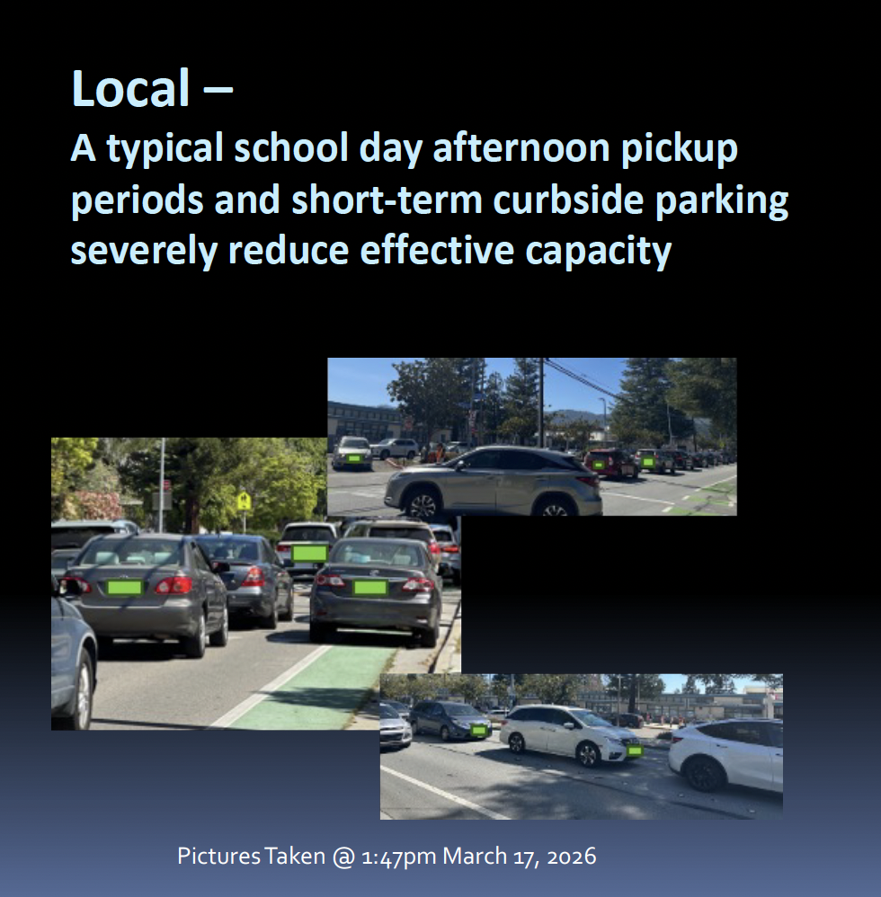
His analysis exposed the real-world conditions that Hexagon’s clear-sky model ignored. He documented Highway 85 traffic backed up during a normal Wednesday morning commute. He showed photographs of local streets overwhelmed during school afternoon pickup periods, with curbside parking further reducing effective road capacity. These are the baseline conditions — before a wildfire adds thousands of panicked evacuees to the same roads.
The core of Kau’s argument was that adding 51 units — generating over 100 additional vehicles — to a cul-de-sac that empties into an evacuation corridor already failing at four times its design capacity is not a two-minute inconvenience. It is a compounding failure. Every additional vehicle in a gridlocked corridor doesn’t add seconds — it adds to the cascading breakdown of the entire system.
Kau put it plainly to the Council: you cannot plan a community’s survival based on a developer’s spreadsheet that erases its children from the map.
The Fire Safety Gaps: What Wasn’t Evaluated
The evacuation problem is compounded by the gaps in the fire safety review that Assistant Fire Chief Estrada identified in his testimony.
The Fire Department’s evaluation focused on the new structures — the 51 townhomes — and specifically on PRC § 4290 setback requirements. It did not extend to the impact on existing homes in the neighborhood.
This matters because of the physics of the proposed design. The project calls for three-story townhomes with one-hour fire-rated walls built just 10 feet from existing single-story homes constructed in the 1950s. These older homes have standard wood-frame construction with no enhanced fire rating. At a 10-foot separation, radiant heat exposure increases dramatically (9x) compared to the code-standard 30-foot setback.
Vice Mayor Chao raised this directly with Estrada, asking how the proposed measures could provide the “same practical effect” as a 30-foot setback when the neighboring homes lack modern fire-resistant features.
Estrada was candid that his department’s enforcement authority stops at the property line — the condition of neighboring structures, their vulnerability to radiant heat, and the adequacy of their owners’ defensible space were not within the scope of the review he was asked to conduct.
The developer’s own third-party fire plan reviewer acknowledged as much on March 17, 2026, stating clearly that being code-compliant does not imply eliminating all hazards and risks.
The compound risk facing Linda Vista residents:
- Evacuation routes that are already at four times their design capacity.
- A fire safety review that excluded neighbor impact, evacuation, and defensible space under PRC § 4291.
- Reduced setbacks that increase radiant heat exposure to unprotected 1950s-era homes.
- A site that sits atop an active fault line.
- And a developer-funded evacuation study that counted only its own residents and assumed perfect driving conditions.
What Residents Are Left With
The families along Linda Vista Drive, Evulich Court, and the surrounding streets are left with a project that was approved based on a version of the facts that doesn’t match the city’s own data. The developer’s evacuation study — voluntary, non-CEQA, and built on assumptions that excluded most of the evacuating population and inflated road capacity by nearly five times — was the only evacuation analysis placed before decision-makers. The city’s own Fehr & Peers study, which showed a catastrophically different picture, was never surfaced.
When Council Member Wang asked the Fire Chief whether evacuation had been considered, Estrada confirmed it was out of scope.
When Wang asked the City Attorney about the city’s liability if a fire caused harm, the answer was that the city would likely be shielded.
The residents, of course, have no such shield.
Resident Ying Sosic captured the human dimension of these numbers at the hearing:
“Think about it as all of us humans, just trying to survive, just trying to get out.”
The data exists to evaluate the risk. The city commissioned it. The question is why it was never placed in front of the people making the decision.
Media Coverage
This story has been covered by local and regional news outlets:
- San José Spotlight: “Cupertino council approves housing in high fire risk area” (April 2, 2026)
- NBC Bay Area TV coverage
- Local news coverage
- Hoodline: “Cupertino Greenlights 51 Hillside Townhomes As Fire Fears Flare”
Continue Reading
- Part 1: The Paper Trail — The full story, end to end.
- Part 3: The Architecture of Approval — The developer’s legal strategy to stretch the record, the staff omissions that enabled it, and the circular argument that silenced safety concerns.
Previously: Who Is Responsible for Fire Safety at Evulich Court? Nobody, Apparently.
Leave a Reply